|
travelog 75

Cañon de la Mano
 Both Echeveria grisea and Thompsonella platyphylla were discribed from the Cañon de la Mano and the Iguala Canyon respectively. These are two good reasons for us to pay a visit to this canyon. To be exact, two visits, one in November of 2004 and another one in December of 2006. On our first visit we had to hike in stifling heat along the railroad tracks as the canyon lies at an altitude of about 900m (2950 feet) above sealevel. We only found one of the plants, Echeveria grisea. The second visit about which we want to tell you now, was a lot more successful.
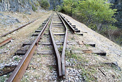
 As in 2004, we want to park our vehicle in El Naranjo between Taxco and Iguala but this time we see a dirt road that was not here in 2004. We learned from our Potosino friends that it's always best to try to get as close to the target as possible because there's always more than enough to explore on foot. That's why we decide to try our luck with this dirt road. Since our last visit the rails had been moved to the side and the railroad embankment had been converted into a dirt road. Driving along this road saves us a lot of hiking and we comfortably reach the entrance to the canyon. Now we are able to see why the road was built. Far below us on the bottom of the canyon we see huge excavators and other heavy machinery parked. Besides, we can already see that a wall is being built that obviously in the end will be the wall of a dam. On the one hand this means easy and comfortable access for us, but on the other hand it is also very possible that with the construction of the dam and a reservoir much would be destroyed in the future. But let's wait and see.
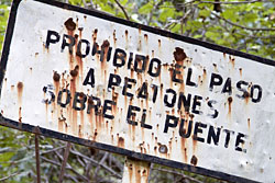
 This time we search the first cliffs for Thompsonella platyphylla. Sure enough the plants grow in full sun and are in bloom. Then, only a few meters farther along, the original railroad tracks are still left to reach and cross the bridge. Inaugurated in 1899, the railroad between Mexico City, Cuernavaca and Balsas never reached its final destination Acapulco. It was only given up very recently in 1997. Not only for railroad aficionados is the most spectacular part of its route the Cañon de la Mano, due to its curved form also known under the name Cañon de la S. The canyon where the railroad ran cuts through a 500m (1650 feet) high mountain. At its mouth we have to cross over the old bridge, a small feat for people with a fear of heights. About 100m (330 feet) above the bottom of the canyon we put one foot in front of the other, always trying hard to step on one of the thick wooden beams on which we have to concentrate hard. At the beginning of the bridge people nailed metal sheets over the beams and every time they bend under the weight of a hiker an eerie bang echoes from the vertical cliffs. Some of the wooden beams are already rotten and others seem to be eaten by animals, but the supporting metal structure looka very stable. Nevertheless we are glad to reach the other side of the bridge and to be back on terra firma!
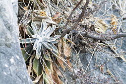
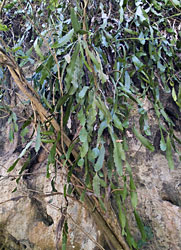
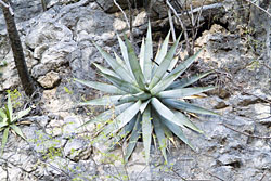 The vertical cliffs are a perfect habitat for different plants. Not far into the canyon we meet a couple that must have come on foot because we didn's see another car. We spot him somewhere up in the cliff where he is playing Tarzan making his way hand over hand from one tree to another. Answering our question as to what he was doing up there, his wife shows us the content of a bag. They collect small, white-spined cacti, Mammillaria nunezii ssp. bella, for the decoration of their family's nativity scene, or probably for selling in the local market. They already have a considerable collection of the plants and now we are not surprised anymore that we can't see any of the mammillarias at a reachable height. There is much vegetation left standing from the rainy season and sometimes the path along the railroad tracks leads through thick, green brush. Huge, big-flowered daisy bushes attract humming insects. Another shrub is adorned with flowers that look like big violets. A wild Chirimoya tree bears fruits but unfortunately they are still unripe. On the opposite side of the canyon many of the deciduous trees still have their green leaves and in between the bright pink flowers of the Amapa trees, Tabebuya rosea, set colorful accents. In the shade and in more moist places we find a Manfreda and a Begonia with pretty pink flowers. Agave angustiarum is at the beginning of its flowering period. A silvery Hechtia however has already produced a spike with hundreds of small white and fragrant flowers. The branching arms of red-trunked Burseras stick leafless into the air. The usually blue-tinted leaves of Pseudosmodingium are gleaming in the colors of autumn. The river bed, at the mouth of the canyon far below us, is coming closer and we finally reach a second, much smaller bridge.
 Echeveria grisea is thriving in the crevices and holes of the man-made stone walls near the bridge. Their delicately pink flowers are visited by a tiny hummingbird with emerald green shimmering back, bluegreen breast and a black head with a short beak and a white stripe above the eyes. He follows us for a while, very curious, singing and chattering, but soon he goes back to his usual business of finding food. Just after the bridge we reach the first very short tunnel. Behind it the canyon widens considerably. We follow the tracks for another while but it looks as if we are approaching civilisation again because the railroad embankment had been cleared of rails and was being converted into a dirt road.
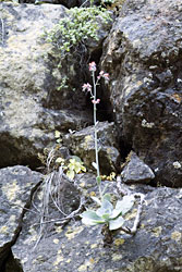 On our way back we hike in the dry river bed for a while. In some parts the sand is still pretty moist and we see clear tracks of different animals. The hoofmark of a deer and the small paws of racoons are easily distinguishable. Then there are bigger paws, either from the vicious dogs people had warned us about, or from a bigger cat, though the former seems more probable. The narrow,m green leaves of an Epiphyllum flow over a big rock. Orchids and Tillandsias are thriving in the trees. Along sunny parts of the cliffs we see a strange bluish cactus with tuberculate ribs, Stenocereus beneckei. Back up at the railroad embankment we make fast progress and soon reach the mouth of the canyon and the spectacular bridge. If one looks down into the depth of the canyon through the wooden beams and the metal structure, even if not suffering from vertigo you can feel quite weak at the knees. The crossing of the bridge is nonetheless a highlight of this hike.
Although it is Sunday, and still early in the morning, we hadn't met anybody on our hike apart from the cactus collecting couple. We had the entire beautiful canyon to ourselves. As a culmination of our trip we treat ourselves to tacos in Iguala, the Cuna de la Bandera Nacional, the cradle of the Mexican flag, where there's really an overpoweringly big flag on a nearby hill, blowing in the wind. In front of the public market at the entrance to town with lots of flea market visitors, we have tacos with grilled meat and chorizo, a spicy sausage. While we are waiting for an empty table, the cook at the barbecue offers us a sample. At another table a woman is busy making tortillas. Our tacos are served with a spicy salsa and grilled onions and chiles. We indulge sinfully on a refresco, a so-called refreshing drink from Coca Cola, the omnipresent soft drink company in Mexico. Afterwards we really feel refreshed and rested and start out to new adventures through the mountains and into the hinterland of Guerrero. Now we hope that we really made your mouth water! Good heavens, no! Of course not for tacos, but for our next travel report which will lead us through the sierras of Guerrero.
January 2007
Julia Etter & Martin Kristen
|


